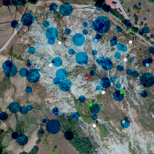
Wireless Sensor Network for Ground Instability Monitoring project
Developed for: International Consortium on Advanced Design (ICAD) - Italy

Requests
- Distance Measuring Sensors
- Position Measuring Sensors
- Data collection and storage
Outcome
- UWB distance measuring technology
- UWB data communication technology
- Development of an ad-hoc network protocol
Strenghts
- Leading edge technology in distance measurement
- Low power consumption
- Very reliable network protocol
- Real time data collection and storing locally and on the web
Specifications
Develop an accurate, flexible and low-cost system for ground deformation monitoring. The Wi-GIM system is based on two types of wireless devices: the nodes (sensor node – SN) and base stations (Base Station – BS). The movement of ground is detected by acquiring the position of each of the SN that are organized in a wireless sensor network (WSN), whose position is determined by integrating two different technologies, specifically designed for the purpose. The data collected by technology 1 are processed with the data collected by technology 2 in order increase the accuracy of the system. The displacements of the landslide can be then displayed in different modes, including 3D.
Problems faced
- Unknown free network topology
- No need of system installation
- Batteries life
- Remote Data Collection
Our Solution
We opted for Ultra Wide Band sensors to have a very good estimate of the distance of two neighbouring nodes. We agreed on using several GPS to locate geographically some of the nodes of the network. Temperatures and batteries status were also monitor and collected. In order to save energy we put to sleep all the nodes, and wake them at given interval, after having accurately synchronised all internal clocks. The protocol we developed is very lightweight, but allows to collect all the data from the network to a given node, store it and send it once a day to a server via a GSM module. Every node measures multiple distances with every other node “on sight”. The multihop protocol provides convergence of all measures to reference nodes. A mesh is thus created and any 3D deformation due to terrain movement is recorded. Data is transferred through a GSM link to a server. Alert SMS can be triggered on the occurrence of several events (excessive movement, low battery on given node, low temperature conditions etc.)Found Solutions
- Custom Network Protocol
- Automatic Network scan procedure in order to self build topology
- Deep sleep and auto wake up procedures. Accurate Clock synchronization.
- Mobile network modem for internet connection, in addition to backup on local mass storage.

